
Upper Uwchlan Township, in northern Chester County is home to a beloved state park, with some beautiful residential neighborhoods nearby. But the Dragonpipe (Mariner East pipeline system) could turn them into a deadly trap. That’s the subject of this blog post.
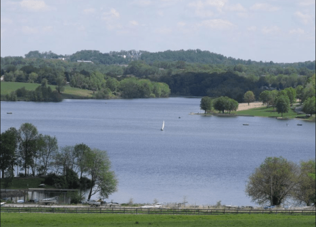
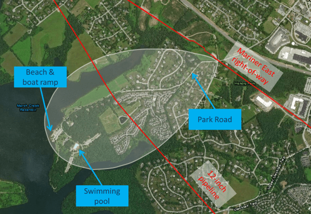
Have you been to Marsh Creek State Park? If so, you may know that the most popular part of it is located on a peninsula: the beach, the boat rental and launch, the swimming pool, and most of the picnic areas. On pleasant summer weekends, that area is crowded with many hundreds of visitors.
The peninsula containing that part of Marsh Creek State Park can only be reached from the east, via Park Road. The lake surrounds the peninsula on the other three sides. Park Road is also the only way to get to over 200 homes that share the peninsula with the State Park. The occupants depend on Park Road for their daily comings and goings.
It’s certainly a beautiful area. There is a potential downside, though: to leave the peninsula, you must cross the Mariner East right-of-way on Park Road. If there were to be a problem with the pipeline, the residents and park visitors would be trapped, with no alternative escape route.
What would happen in case of a rupture? If a rupture occurred near the point where the pipelines cross Park Road, there could be very serious consequences. A rupture of the 20-inch ME2 pipeline, combined with a gentle breeze blowing to the west, would be the worst case. (Sunoco will tell you this combination of factors is very unlikely, and that is true, but disasters are almost always caused by highly unlikely circumstances. For example, last fall’s explosion of a brand new Sunoco pipeline in Beaver County was caused by factors that Sunoco would have considered very unlikely.)
The material escaping from the rupture would immediately revert to a gas and would form a low, explosive cloud, drifting to the west with the wind. It would expand until its edges were too diluted to still be flammable. The extent of such a cloud after 10 minutes is shown in the aerial view below. (My process for creating this illustration is described here: How I model a local pipeline accident.)
Suppose Sunoco detected the rupture and alerted local authorities; also, suppose the authorities were somehow able to alert those in harm’s way. What should they do? Sunoco’s stock answer is “immediately walk upwind and uphill to a safe area”, but in this situation that would require walking directly toward the rupture. Unless you were a good swimmer, every other option for escape would be prevented by the lake. Knowing about the rupture would be of no help.
Sooner or later, the cloud would encounter an ignition source. At that point, anyone outdoors in the cloud (and many of those indoors) would be killed by the resulting “flash fire”. The houses in the cloud would be set on fire.
But that would not be the end of it. Back at the rupture point, a ferocious “jet fire” (like a giant blowtorch) would continue burning until all the gas was gone. Even if Sunoco had immediately shut off the nearest valves at either end of the 6-10 mile stretch of pipeline, the burning would continue for many hours. There is no way to extinguish a jet fire. If the rupture was near Park Road, the jet fire would prevent rescuers from getting in, and no one would be able to get out. Can you imagine how grim that situation would be?
And what about the 12-inch line? The old 12-inch pipeline (part of the “Frankenpipe” pipeline that Sunoco cobbled together out of various sizes and ages of pipeline) also runs through this area, but it takes a different route. It cuts across the peninsula farther toward the park than the main Mariner East right-of-way. Right now, it already has highly-volatile liquids flowing through it.
If there were to be a rupture or a serious leak on that pipeline, it could cut off access to the state park and to about 50 homes on the peninsula (specifically, those on Larkin’s Bridge Drive and Carpenter’s Cove Lane). The flammable cloud produced would be smaller (because the pipeline is smaller), but just as deadly. It could totally cut off the only escape route for residents of those streets and for park visitors.
What’s the plan? It should be obvious at this point that a rupture like either of those described above would be a major disaster. Hundreds would die. (On a summer weekend, it could be thousands.) Do the local first responders have a plan for dealing with something like this? What could they even do?
Get involved. Let your township officials and state representatives know that this situation is not acceptable. (You can look up your state representatives at https://www.legis.state.pa.us/cfdocs/legis/home/findyourlegislator/) We cannot ask hundreds of people to risk their lives for the sake of Sunoco’s profits and Europe’s plastic manufacturers. The governor needs to hear from you too: he could put a halt to this on his own.
If your municipality has a pipeline safety group already, join it and get active. If it doesn’t, then get a few neighbors together and start one. Organize a local public meeting about the pipeline. It’s easy to arrange for a speaker and a presentation. Write to me via the “Contact” menu of this blog and I’ll help you.
Until Sunoco can demonstrate that there is a way to operate this pipeline without putting these lives at risk, we need to insist that all construction be halted and that the flow of explosive materials through the existing pipelines be stopped.
PS—Coming soon: Within the next few days I will be writing about Sunoco’s proposed pipeline construction crossing Little Conestoga Road, not far from Marsh Creek State Park. Be prepared to send a comment to the Department of Environmental Protection, which depends on our feedback to determine whether to issue a permit. Comments will be due Tuesday, June 11.

We are one of the 200 homes – Heron Hill Drive
LikeLike