
Wellington at Hershey’s Mill is a large senior living complex in Chester County. The route of the Dragonpipe (Mainer East 2 pipeline) runs by the main entrance. That means we need to know what the residents would be facing in the event of a pipeline accident. Using software designed for modeling the consequences of leaks of volatile gas, I was able to assess the possible scope of damage from a Dragonpipe rupture affecting the Wellington complex and the surrounding area.
The modeling software. The Citizens’ Risk Assessment, initiated by State Senator Dinniman, was recently completed by Oklahoma-based Quest Consultants, Inc. (Quest’s final report is expected within a few days.) As part of that project, a 3-month license to use the associated CANARY software was also obtained. The software allows the user to perform “what-if” analyses of various scenarios of the release and ignition of the highly-compressed gasses carried by the Dragonpipe. The information that the user enters includes the size of the leak, the material being transported, its pressure, and how soon after release the gas finds a source of ignition. This software has been widely used in the petrochemical industry to model many kinds of fires, explosions, and lethal gas leaks. The software can produce a diagram, such as the one that appears later in this post, that shows the extent of the “flash fire” produced by the specified leak.
I had the opportunity to try using the CANARY software to model leak scenarios in the vicinity of the Wellington facility. To me, the results are frightening.
First let’s consider how Wellington is arranged. There are 193 apartments for independent living, 64 apartments for assisted living (for residents who need help with their daily tasks), and 40 beds in the nursing facility. Depending on the occupancy rate and how many of the apartments have more than one resident, there are likely to be around 350 residents and perhaps 50 staff and visitors at any given time. The only vehicle access to the facility is from Carriage Drive, the access road off the nearby main road (Boot Road). Carriage Drive runs along the southwest side of the facility, and the Dragonpipe right-of-way runs along Carriage Drive.

This arrangement means that, if there is a pipeline fire that blocks access to Carriage Drive, Wellington would be cut off from all vehicles. No one would get in or out, except on foot.
Modeling a vapor cloud release. I modeled several possible scenarios. The one shown below is for a rupture occurring right in front of the Giant supermarket, adjacent to Wellington. Since I am a new user, I had Quest review my results, and they confirmed that I used the software correctly.
I assumed the leak would continue for 10 minutes before the gas encountered an ignition source. I also assumed a total rupture of the pipeline 20″ Mariner East 2 pipeline, I assumed that propane was the gas being transported, and I assumed light winds (1 mph) from the southeast, with the leak facing in the downwind direction. Each of these assumptions represents a worst-case condition, but in emergencies, the worst case is the case you need to be ready for.
Arguably, the case I looked at is not even the worst case. I assumed that only the 20″ Mariner East 2 line was involved. It is certainly possible that a severe fire on Mariner East 2 could cause the failure of Mariner East 1 (8″) or Mariner East 2X (16″). All of them lie in the same easement, and all could become involved, if Sunoco keeps all of them in service (which they will surely be tempted to do). The added failure of one or more of these other pipelines would greatly increase the severity and extent of damage.
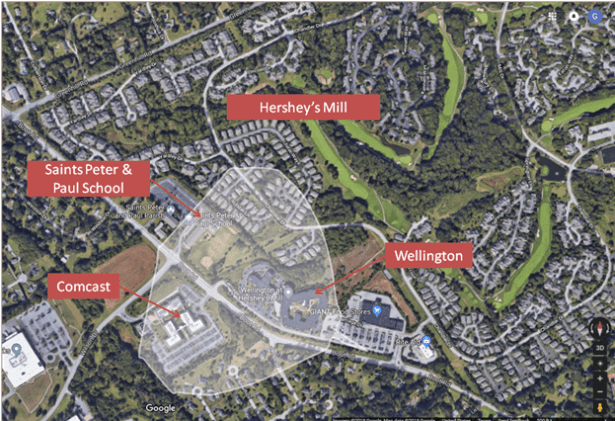
Severe damage to Wellington, Comcast, and much more. So what did the CANARY software show? In the situation I modeled, the leaking gas quickly forms a large vapor cloud, which spreads to the northwest, enveloping the entire Wellington facility, the entire Comcast facility across the street, and parts of the Saints Peter and Paul school and about 40 homes in the Hershey’s Mill retirement community. Within just four minutes, the cloud would have reached an extent of about 2200 feet downwind, with a width of about 2400 feet. Some of the gas would travel even farther, but would be sufficiently diluted (by mixing with air) that it would not burn.
The outer edge of the gas that can catch fire is called the “lower flammable limit” (LFL) and is shown by the outline on the Google image below. Gas that spreads beyond the LFL will dissipate without burning.
Upon ignition, flames would engulf everything within the lower flammable limit in a “flash fire”. Anyone who was outdoors would be killed instantly. Being indoors could provide some protection, but there would probably be many immediate indoor deaths as well.
The flash fire would last less than a minute, consuming the entire cloud of gas and setting most of the structures within it on fire. After that, the flash fire would transition into a huge blowtorch-like “jet fire”, pointing toward the Wellington. A sense of the magnitude of the jet fire can be gotten by looking at photos of the natural gas leak in San Bruno, CA, in 2010, such as the one below.

The videos of the San Bruno event are even more dramatic. Examples are here and here.
The Dragonpipe would create an even bigger fire than the one in San Bruno. (Its diameter is smaller than the San Bruno natural gas pipeline, but the highly-compressed and liquefied gasses involved pack far more punch than natural gas.)
The fire can’t be extinguished, so residents can’t be rescued. The jet fire would continue for many hours. There is no way of extinguishing such a fire, except to shut off its gas supply and allow the gas remaining in the pipe to burn off. (That’s what is happening in the San Bruno videos linked above.) The heat from the jet fire would be such that some parts of Wellington near the fire would be destroyed by it, even if they survived the initial flash fire.
Fire trucks would not be able to get near most parts of the Wellington complex because of the heat. In addition, the direct route from the nearest fire station (at Boot Road and Route 202) would be blocked by the flames of the jet fire.
Similarly, rescue personnel would not be able to get into the Wellington complex. The side entrance is near the Giant parking lot, and the other principal entrances are onto Carriage Drive. These would all be blocked by the fire. Wellington occupants who survived the initial flash fire might be able to escape on foot out emergency doors on the north side of the complex, but given the age and frailty of much of the Wellington population, many would be stuck inside. And there is no vehicle access to the north side of the complex.
So what does Sunoco suggest doing in such a case? They provide only the generic instruction for residents to walk upwind on foot in case of a leak. But that obviously makes no sense in this case. Walking upwind, in this example, would be walking toward the fire. And at Wellington, we are dealing with a large group with limited mobility. It is a recipe for disaster.
Could it happen? Sunoco will argue that an event of the kind I have modeled is very unlikely. That is true, but such events do happen. The event in Follansbee, WV is an example involving a pipeline that is similar to the Dragonpipe in size and content. It was less than two years old when it ruptured. Fortunately, it occurred in an area that was sparsely settled. No one was injured. The nearest house had its vinyl siding melted from the intense heat but was not destroyed. By contrast, no part of the Wellington complex is as far from the Dragonpipe as that house was from the pipeline in Follansbee. I would challenge Sunoco to show why a Follansbee-type event could not happen at Wellington.
Could it happen elsewhere along the Dragonpipe? Of course it could. The same type of modeling can be applied at any location along the Dragonpipe. There are factors that make some areas more vulnerable or less vulnerable than Wellington (the presence or absence of valve stations, the distance from the nearest pumping station, the slope of the land, the presence of valleys and low spots, the presence of trees) that could affect the scope of the damage, but all those effects are relatively minor. If you take the diagram shown here and superimpose it on any location along the pipeline, you can get a pretty accurate idea of what the consequences of a rupture at that location might be.
PS: Help us keep this software permanently! The Canary software is very flexible. It can be used to model the consequences of a leak on any pipeline (not just the Mariner East system), carrying any flammable material (not just NGLs), and at any location.
The group involved in raising money for the Dinniman-initiated risk assessment has succeeded in raising enough to pay for the risk-analysis report, but not enough for a permanent software license. I believe we will need to know the consequences of leaks on many proposed pipelines for years to come. If you share the belief that it is important to retain the ability to do analyses like the one in this blog post—for any location and any pipeline—please contribute to this cause. Details are here.

George, your analyses are very thoughtful and informative!
LikeLike